

GOSHEN COUNTY – Much of eastern Wyoming dodged a bullet as an anticipated winter storm last week didn’t hit as hard as early predictions said.
The storm was “pretty typical for this time of year,” said meteorologist Jerry Claycomb with the National Weather Service in Cheyenne. “The system tracked a bit further north than what we were thinking it would and (moved through the area) a lot faster.”
The bulk of the storm hit the Pine Ridge region of northwest Nebraska, which reported as much as 12 inches of snow. Portions of the storm line dumped as much as five inches in areas of Laramie County and around Cheyenne, including measurements of three inches at the Cheyenne Airport, where the National Weather Service is officed, Claycomb said.
Snowfall amounts from the storm varied in Goshen County, from an inch in southwestern Goshen County to 3.5-inches north of Hawk Springs. Warm weather in the days before the storm moved in means the actual totals may be greater, Claycomb said. Warm air means warm ground, which probably melted some of the first flakes that hit the ground in eastern Wyoming and western Nebraska, skewing the final snowfall totals.
“That’s pretty typical for these early-season storms,” Claycomb said. “The ground is just too warm. As we get deeper into the winter season, the ground will be colder. A lot more of that snow will remain.”
While the timing of the storm wasn’t out of the ordinary, 2019 has been anything but an average weather year, Claycomb said. Since Jan. 1, the NWS office in Cheyenne has issued more than 400 severe thunderstorm warnings.
“We’ve never done that before,” he said. “We’ve never had that many warnings for a season. It was pretty active for us.”
Part of the cause for the unusual weather year was a weak El Nino pattern that developed in the opening months of 2019, Claycomb said. That drove the regional climate “straight into the monsoon season.”
Weather fronts originating in Canada typically keep the region cool and damp into early May. Then they retreat back north to be replaced by dry weather systems from the desert southwest, he said. When monsoon season kicks in, moisture out of Mexico and the Gulf of California triggers rains later in the season.
“That keeps us dry through probably June or so,” Claycomb said. “But that started earlier this year – it started in June and persisted through most of the summer.”
That was a mixed blessing for farmers, particularly those who lost irrigation water in July following the tunnel collapse on the Gering-Fort Laramie Canal, said Dr. Cody Creech, a dryland cropping specialist at the University of Nebraska Panhandle Research and Extension Center in Scottsbluff, Neb.
“The question on the canal collapse would be if the fields were able to get water before the canal went out,” Creech said. “The fields that didn’t get water prior to the collapse, those fields are going to hurt a little more. We got really fortunate with the timely rains that helped out.”
Still, Creech wouldn’t be surprised to see losses of 15 to 20 percent over last yields around the Wyo-Braska region. But, fortunately, the most recent storm didn’t have as many negative effects on farmers as it could have.
“The thing that could have happened is (snow) weighing down stalks,” said Carrie Eberle, Assistant Professor of Agronomy and Cropping Systems with the University of Wyoming at the James C. Hageman Sustainable Agriculture Research and Extension Center in Lingle.
“Having ears on the ground – once that happens, it’s pretty hard to recover from it,” Eberle said. “And I think the weather conditions while the canal was down really helped delay the drought stress those crops were having.”
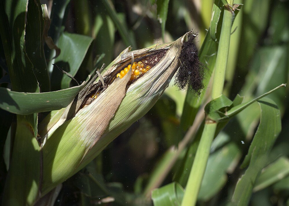
Most of the Wyoming corn crop – 75 percent – had reached maturity by the time freezing temperatures hit, according to the Oct. 7 Wyoming Crop Progress Report from the U.S. Department of Agriculture National Agricultural Statistics Service field office in Cheyenne. After that point, all freezing temperatures will do is help dry the plants down in preparation for harvest, Eberle said.
The crop is “mature – not ready to harvest but mature to the point where having cold on it should not significantly impact it, at this point,” she said.
Even with everything, there were a couple of bright spots for some producers this year, Eberle and Creech said. For one, dryland farmers outside the Platte River Valley could see a bumper crop this year, Creech said.
“The summer really helped the dryland crops, because we had better moisture,” he said. “Dryland yields outside the Valley are going to be really nice this year. A lot of those fields will be breaking 100 bushels this year.
“To say overall, are we going to see more corn or less produced this year?” Creech said. “I don’t know. I feel those dryland acres are going to make up some of that difference this year.”
Another advantage to the cooler, wetter summer was reduced heat stress, decreasing demand for irrigation water that wasn’t there in parts of the Valley, Eberle said. Particularly for the producers who lost water in the canal shutdown, “even a quarter-inch of rain can delay some of those drought impacts,” she said. “I think the weather conditions while the canal was down really helped delay the drought stress those crops were having.”
And if anyone is going to see a benefit from this first storm of the season, it’s winter wheat producers, Creech said.
“Nothing about this storm, as brief as it was, would concern me about the wheat crop; the moisture could be seen as a positive for some of that wheat,” he said. “If it warms up next week, that moisture could definitely be a benefit.”
But Eberle and Creech both said, regardless of whether they were impacted by canal or not, the weather all season will definitely take a toll on production this year.
“The bottom line is – corn likes heat,” Creech said. “We’re going to see yields off just because we didn’t have all the heat it likes to have.”


