

Last week, man and machine joined forces in an attempt to control an unprecedented – yet recurring – natural disaster that routinely strikes rural Goshen County.
This item is available in full to subscribers.
To continue reading, you will need to either log in to your subscriber account, or purchase a new subscription.
If you are a current print subscriber, you can set up a free website account and connect your subscription to it by clicking here.
If you are a digital subscriber with an active, online-only subscription then you already have an account here. Just reset your password if you've not yet logged in to your account on this new site.
Otherwise, click here to view your options for subscribing.
Please log in to continue |
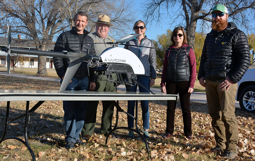
FORT LARAMIE – Last week, man and machine joined forces in an attempt to control an unprecedented – yet recurring – natural disaster that routinely strikes rural Goshen County.
In 2015 and 2016, Fort Laramie National Historic Site experienced the effects of a 100-year flood – an event that has a 1-percent chance of occurring during any given year.
Severe erosion along the Laramie River, closed and washed out park trails and roads, and potential damage to irreplaceable historic buildings prompted Superintendent Tom Baker to reach out for help.
“The park has experienced two, 100-year flood events … and the superintendent called to say ‘Is this the new normal? I think what I need is some sort of river management plan,’” Don Weeks, physical resources program manager for the Intermountain Region of the National Park Service, said.
Nell Conti, also of the Intermountain Region Geographic Resources Division, said part of the recommendation to begin flood management planning included collecting high-resolution, photogrammetric surveys, in addition to light detection and ranging (LiDAR) data – which uses eye-safe laser pulses to measure elevations and provide an accurate, three-dimensional map of the area surveyed. For this, the team turned to Mark Bauer and Todd Burton of the U.S. Geological Survey’s Unmanned Aircraft Systems Project Office.
“Our office previously worked with Mark and Todd on a project for Devils Tower,” Conti said. “We reached out and said we believed (Fort Laramie NHS) is small enough to warrant unmanned aircraft, which is much more cost effective than airborne LiDAR manned flights.”
Project planning began approximately eight months ago, in February, and last week, Bauer and Burton brought an $80,000 drone to the park – complete with an estimated $70,000
LiDAR payload.
“We came up (from our Denver, Colo. office) Monday,” Bauer said. “We did safety briefings on Monday … and actual flights occurred on Oct. 17th through the 19th.”
Bauer and Burton completed a total of 11 flights, most of which were at 150 feet above ground level, with a few flights at 400 feet above ground level.
“We covered the area of the park that potentially could be flooded – over the river channel, we focused on that region, and other parts as well,” Bauer said, adding flood plain mapping was the primary concern. But there was also the possibility of revealing previously unknown archeological data about the site as well.
Throughout the week, the team worked from 6:30 a.m. to around 4:30 p.m. to acquire the data.
“One reason we picked this time of year is the leaf-off,” Bauer said. “The more leaves off the trees, the better to scan and photo surveys are able to detect the ground better than with more forest canopy around. A little less visitation (at FLNHS) this time of year made it easier for us to accomplish the flights and minimize the impact on the park.”
Bauer added the drone can’t fly in a snowstorm, rainstorm or over people due to safety concerns. Bare ground is ideal.
“We use the photos to put together a 3D model of the surface,” he said. “We also use LiDAR, (which offers) a much more accurate representation of the trees and areas below the trees, and can eventually create bare-earth models.”
The completion of LiDAR and photogrammetric surveys at the park represent a major step forward for FLNHS, although the overall project is far from complete.
“This work is a component for that, how (FLNHS) is going to manage with these flood events, what sort of proactive things they’re going to be doing,” Weeks said. “Elevations are very important for modeling different stages of flow, what the impact will be, what assets will be affected, and (the park) can react accordingly – it feeds that bigger objective, and LIDAR is a critical piece of that.”
Friday morning, the team debriefed in the FLNHS Visitors Center.
“This is a big coordinated effort between the National Park Service and USGS – a lot of team members, aviation managers, getting the permits, safety folks for the park, flight operators,” Bauer said. “Everything went really well this week in terms of getting what we needed and getting it done safely.”
Bauer estimated USGS will take a few weeks to process and deliver its findings back to the National Park Service, which will then perform additional data analysis and begin making flood plain management decisions.
Weeks did not expect a new plan to be in place by the 2018 flood season, but the most recently acquired photos and models will give his office a good place to start.
“This was a huge information need,” he said. “Since we have it now, we can build it.
“It will depend on funding and organization, but I suspect (flood management at FLNHS) will be a priority,” Weeks said. “I think it’s probably going to take a combination of some funding and in-house support, but we’ve got momentum.”


